

Advocacy
SABA makes Sacramento a safer place to ride a bike for all kinds of trips through its work with Complete Streets, Vision Zero, bike networks, and advocating for legislation that improves bicycle infrastructure.
Current Issues
COMPLETE STREETS
Complete Streets provide safe access for all users, regardless of age, ability, and mode of transportation.
SAFER STREETS
Sacramento’s Vision Zero's goal is to eradicate all severe injuries & deaths caused by traffic collisions by 2027.

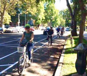
CONNECTIVE BIKE NETWORKS
Sacramento needs a complete, connected low-stress bike network.

HOW TO ADVOCATE
SPEAK UP! Be an advocate for better cycling infrastructure in the City of Sacramento.

OPEN STREETS
Temporary closures of streets to autos allow people to use the streets for a variety of activities.

MAY IS BIKE MONTH
Every May we celebrate our local bike culture and encourage riders to replace their car trips with bike trips.
Current Advocacy Issues
CARB's E-Bike Incentive Program
- CARB has quietly shuttered its e-bike incentive five program and will redirect the remaining 17 million to subsidize Clean Cars 4 All. This re-enforces car culture and does not move us towards your climate goals. Nor does it help our low income neighbors who, if awarded, would have a reliable means of transportation. Instead of helping replace car trips, CARB is rewarding people who already own one. Please join us in sending a message to fully restore the E-bike Incentive Program.
Closure of Causeway Bike Path
- Background: The I-80 Causeway Bike Path is part of the main route cyclists use travelling between Davis and Sacramento. It is well-traveled, with over 200 cyclists (including approximately 100 students) using the path per day. PG&E is going to be conducting a pipeline replacement project across Prospect Slough in West Sacramento. They are saying it will require the closure of the I-80 Causeway bike path for approximately four months total over the course of two years, starting in 2027. This project is a horizontal drilling project to replace the pipeline under the Yolo Bypass.
- Status: PG&E, Caltrans, and the City of West Sacramento with input from SABA are looking into options for cyclists when the bike path needs to be closed.
- What you can do: You can email contacts at the various parties involved to let them know which option you think is best - see more information and who to contact.
Red Light Camera Bill - SB 720 - Update - Success!
- On October 13, 2025, Governor Newsom signed SB720, lifesaving legislation that supports cities in better taking on one of the most dangerous driving behaviors: red light running.
Bike Highways Bill, AB 954
- Background: CalBike is sponsoring the Bike Highways Bill, AB 954, which would add bike highways to state transportation planning, encouraging local and regional governments to build on existing bicycle infrastructure and to create the connected transportation networks.
- Status: The bill was referred to the Appropriations Committee on July 9.
- What you can do: Sign the CalBike petition.
- More information from CalBike