


Finding Comfortable Cycling Routes
Explore some different applications for making cycling in the Sacramento region and other places more comfortable and less stressful.
SABA wants everyone to feel safe and comfortable choosing cycling over car trips, but we know that sometimes it's difficult to find the best route to get from point A to point B. Fortunately, there are some online and phone applications to make the task of developing low-stress bicycling networks easier. These applications allow you to access routes suggested by local cyclists, as well as to submit suggestions of your own.
Sometimes application based cycling directions put you on an uncomfortable or unsafe route - like directing you to a freeway, so always check the recommended route(s) before following them.
Here are overviews of some of the main applications:
Sometimes application based cycling directions put you on an uncomfortable or unsafe route - like directing you to a freeway, so always check the recommended route(s) before following them.
Here are overviews of some of the main applications:
Ride with GPS
Description
- Ride with GPS helps you plan, navigate, and share cycling routes worldwide. Its app and tools empower cyclists of all levels to explore and modify routes. Explore SABA’s map library on Ride with GPS showing you the best places in Sacramento to ride - includes free turn by turn navigation!
Plans
- Starter (free):
- Explore routes & rides
- Record rides in the mobile app
- Plan routes on the website
- Sync with Garmin, Wahoo, GPS devices & cycling computers
- Basic ($5/month)
- Everything from Starter plus:
- Turn-by-turn voice navigation
- Offline maps
- Live logging
- 7 & 30 day heatmaps on mobile
- Premium ($6.67/month)
- Everything from Basic plus:
- Our most comprehensive planning & editing tools
- Full access to 7 day, 30 day, and all time global & personal heatmaps
- Generate custom cues
- Analyze & clean up rides
- Print custom maps
- Set unlimited privacy zones
- Create private segments
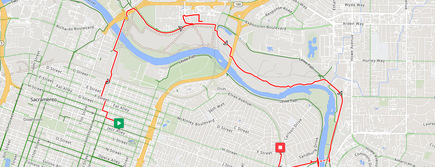
How to Use Ride with GPS
Drawbacks
- User interface isn't very intuitive.
Google Maps
Description
Google Maps, while having lots of room for improvement, is a great free tool for finding bike paths and directions. They keep track of all the bike trails, dedicated bike lanes, bike friendly streets, and even bike friendly dirt/unpaved roads. But this display is not on by default (and doesn’t show up even if you get Biking directions), so you have to turn it on to do your route research.
- On mobile: Tap the layers icon in the top left corner, then tap the Biking details layer
- On desktop: Hover over the “Layers” icon in the bottom left corner, then tap the Biking details layer
- Look for the long solid green lines that indicate either a bike trail or a dedicated bike lane. It’s also handy to see what the bike lane or trail really looks like on Street View. Off street trails often won’t have a Street View, which usually means it’s a path away from vehicle traffic.
- For more information about using Google Maps for cycling see: Bike to Everything.
- You can also create custom maps using Google MyMaps.
Drawbacks
- Sometimes Google map cycling directions put you on an uncomfortable or unsafe route - like directing you to a freeway, so always check the route by type of road.
Bikemap
Description
- Use Bikemap's route editor to plan the perfect route for you. Select road bike, mountain bike or e-bike and choose between popular routes. Tailor your search using filters for distance, elevation, surface type, round-trip routes, and more — or simply filter by route name. Or choose from their ready-made presets like Gravel, Road, or Relaxed rides and start exploring. Routes come with detailed stats, elevation profiles, and surface info.
Cost
- All plans give access to Premium features, which include:
- Advanced route planner - optimize by bike type and cycling style
- Advanced cycling maps - access smart map layers developed for cyclists
- Print and export - get your route on paper in GPX or KML file form
- Turn by turn navigation - voice directions and visual cues
- Self-guided navigation - navigate off-road segments and undefined paths
- Offline maps & navigation
- Custom bike computer - view your personal cycling data in the layout of your choice
- Detailed route preview - with colored elevation gradients or in 3D
- Battery save mode
- Weather forecast - detailed weather by route and time with wind graphs
- Monthly - $10.40 - free trial for 3 days; cancel anytime
- Annual - $45 - free trial for 3 days; cancel anytime
- 3 Years - $114 - one-time payment; expires automatically
Komoot
Description
- Komoot helps you generate sport-specific routes tailored to your needs and preferences, whether you're looking for smooth asphalt for your road bike, singletracks for your mountain bike, or peaceful trails for your hikes.
- You can connect komoot with other devices and services to sync routes and recordings.
- View inch-by-inch surface, way-type and elevation analysis in the planning panel, and always be aware of what’s coming well ahead of time.
- Komoot makes it easier to differentiate between hiking paths, singletracks or paved roads at a glance, and lets you view detailed terrain and landscape data so you always know what to pack.

Cost
- All plans include:
- Voice navigation
- Offline maps
- Weekly updates
- No recurring costs
- Single Region: $3.99 one time payment.
- Region Bundle: $8.99 one time payment.
- The World: $29.99 one time payment.
511CC’s Bike Mapper
Description
- 511CC's Bikemapper is a free bike mapping system, managed by Contra Costa county, that is specially designed to find flat, safe, and fast routes anywhere in the San Francisco Bay Area. You can filter routes by mostly bike paths and lanes, a reasonable route, and a more direct route, as well as how many hills you want to tackle. It doesn't currently have data for Sacramento.
- Doesn't combine cycling with public transportation, so some routes are not very practical.
Cycle Travel
Description
- Cycle Travel is an international route-planner application that aims to find you the most enjoyable bike route. Cycling is best when there are few cars. so Cycle Travel routes you along traffic-free paths and quiet lanes, using real traffic data to identify the roads with fewest motor vehicles. Their algorithms analyze landforms and features to choose the most scenic roads and paths, preferring glorious valley roads and peaceful waterside trails to paths beside busy highways.
Cost
- The app can be used for free or you can join as a member for a monthly fee:
- Coffee: $2/month - You'll get a monthly cycle.travel supporters' newsletter; extra features including satellite maps, UK Ordnance Survey maps, French IGN maps, and weather forecasts.
- Cake: $5/month - You'll get a monthly cycle.travel supporters' newsletter; previews of new features before anyone else sees them; extra features including satellite maps, UK Ordnance Survey maps, French IGN maps, and weather forecasts.
- Beer: $10/month - You get all the Cake benefits plus your name in lights at the top of the supporters' page.
Strava
Description
- Strava lets you record 50 different types of activities, including cycling, with features to help you explore, connect and measure your progress. More than 150 million users in over 185 countries use Strava, so whatever your activity and goals, you’ll have a community at your back. Strava athletes upload everything from walks around the block to Tour de France stage wins. Strava records and logs ride taken with Ride with GPS.
Cost
- Subscription features include routes, segment leaderboards, advanced training analysis and more:
- Individual: $11.99/month or $6.67/month if you pay for a full year in advance.
- Family: $2.92/month/per person. Plan billed for 4 members at $139.99/year + tax. Annual only.
- Student: $3.33/month, billed annually at $39.99.
- Strava + Runna (a running coaching app): $12.50/month billed at $149.99/year + tax. Annual only.
For more information about cycling apps, see Best cycling apps for route-planning and navigation 2025, from Cyclist